
From: casarollnotes.blogspot.com
Tim and Linda Bunyan
Tim and Linda Bunyan
From one Grand Canyon (North Rim) in Arizona we travel north about 100 miles to the next "Rock Star": the steep red cliffs of Zion National Park in Southwest Utah.
But FIRST along the road, we notice an Open sign and this beautiful Visitors Center building. We came upon it in a moment of time and place. We discovered others came to this special place and found it their home.


PIPE SPRINGS National Monument in Arizona caught our eye and Tim made a quick
U-turn to discover the welcoming life source in this high desert between the Grand Canyon and the foot of the Vermilion Cliffs of northern Arizona.

Between 1000 and 1250 ancestral, sedentary Puebloan peoples' culture gradually faded to the seminomadic Southern Kaibab Paiutes. They lived in natural shelters or built kahns of juniper branches and brush.

They lived outdoors during the day and slept in these shelters with their feet warmed by the evening fire.

In support of Mormons to expanding into Arizona, Jacob Hamblin stopped at Pipe Spring in 1858. Legendary Colorado River explorer John Wesley Powell first visited the Spring in 1870 and his survey crews camped and supplied here to promote peace between the Indian tribes and Morman settlers.


Ranchers began settling near water sources on the Arizona Strip (the land between the Colorado River to the south to the southern border of Utah to the North) in the 1860s.
In 1868
militiamen built a small stone cabin as a stronghold to again
strength against continuing Navajo raids in the region.


The herdsmen lead an active life and seem to live on horseback constantly running after their livestock, or bringing them back from the furthest reaches of their ranches. They must brand the newborns with the special stamp that each owner has to identify animals in his herd.
Pipe Spring was the headquarters of the Winsor Castle Stock Growing Company, the South Utah Tithing Office of Cattle Herds, and later the Canan Cooperative Cattle Company ....
all owned thousands of head of cattle.
We came to understand the luxury of the kerchief used by the cowboys. In the heat of the area, the cloth can be used to cool and clean and as first aid.

The Winsor Castle Headquarters Tithing Office (below). Now, self-guided tours of the grounds are offered by the joint Tribal-National Park Service visitor center and museum. This history of the Kaibab Paiutes and the Morman settlement is given by Ranger talks and the Ridge Trail offers dramatic views of the Arizona Strip, Mount Trumbull, Kaibab Plateau, and Kanab Canyon.

The Spring at this remote fort at Pipe Spring ranch remained open to travelers, cowboys, traders, salesmen, and neighbors throughout the 1800s.
Steven Mather, the first director of the National Park Service paved the way for Pipe Spring to become a national monument. Tourists were carried by bus from Zion to the North Rim of Grand Canyon, across the Arizona Strips's hot, dusty roads.
May 31, 1923, President Warren G. Harding proclaimed Pipe Spring a national monument.

ZION NATIONAL PARK, Utah
The entrance to Zion National Park is lined with conveniences for the traveler. The town of Springdale is beautifully equipped to provide the tourist with outdoor gear, grocery needs, and even coffee cafes!

Through hard work and faith, the new residents endured in a landscape where past flash floods destroyed towns and drought burned crops.
Now exists: Canyon Corridore Housing development (circa 2020)!

Everything in Zion takes life from the Virgin River's scarce desert waters.

Zion draws new explorers to experience the beauty and the sanctuary of this place that generations have considered home.


Along the dramatic edge of the region known as the Colorado Plateau. The rock layers have been uplifted, tilted, and eroded, forming features of colorful cliffs stretching from Grand Canyon to Zion, to Bryce Canyon!


We are at the National Park entrance to the heavenly kingdom of
ZION National Park!

This is our RV campground at the standout Watchman Rock formation.


We find our site located next to a running stream that is diverted
under the campground road by a culvert.


As prepared as the cowboys that came before us, Tim provisioned us with Shuttle Tickets at Recreation.Gov. prior to our visit. Like the old days of the horse, the Shuttle transports the visitor to stops along the Scenic Drive in Zion National Park. Walking the Scenic Drive is long and hot and not recommended. Bicycles can be rented but must ride single file and pull over and stop to allow shuttle buses to pass.


We start our walking trail at the Temple of Sinawava shuttle stop deep into the Zion Canyon.
This simple cottonwood tree magnificently spans much of the green space providing shade and visual serenity here at the Lodge.


The lovely setting at the (closed) Visitor Center remains a focal point to enjoy our bagged lunch and some open green space. We actually found an available bench for ease to take in this pleasant scene.

On our first trail we choose the Riverside Walk. On the trail, we pass through lush vegetation--a desert swamp. It does rain here and with spring run-off the low ground is always moist with a cooler, greener microclimate of ferns and mosses.
The Virgin River pumps life into this desert canyon.


Water from the Virgin River transforms desert to oasis.

Like an unhurried artist, oak, cottonwood, and willows linger on the Virgin River banks.

We soaked up many views along the paved walking trail along the Virgin River.

through the water of the Virgin River


Many rock walls are 1,000 feet tall in Zion Canyon.


 Like an unhurried artist, the walls of rock and cottonwood and willow trees adorn Zion!

 The portion of the trail was restored this season as a flash flood took away the original trail. Now steps concreted with a rope handrail to gain access to the top of Emerald Pool Trail.

 We have hiked to the viewpoint looking down on the waterfall.
We've hiked over a mile and the peaks of the canyon walls are still above us.
 The Emerald Pool.


 OK, no leaks........the water is only an inch deep to start!

 Now I am holding up the leg of my shorts so my clothes do not get wet.

 Tim is directing other hikers where they are located in the proximity of The Rock and The Narrows.

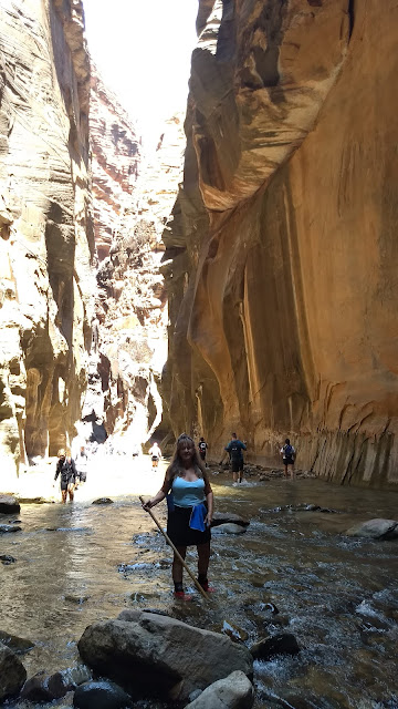
At the beginning of the wading trail, there are many hikers; some wore masks.
 As we enter into the narrow walls of the canyon the air is cooler and fewer hikers venture.

 There are over 30 other hikers wading up the Virgin River through The Narrows. Many have the water boots, the same as we rented. Assorted shoes are worn by other hikers.
This is The Rock. It is huge as our Travel Trailer! We keep going past it on the wading trail. Now, few other hikers are on this journey.
 I took a break on this white rock beach but resumed another mile on this wonderful wading trail.
 Tim is fascinated and taking photos as he waits for me to catch up.
 I do have a pole and using the steady of the canyon wall to ensure my step.
 Tim is quite comfortable in his wading trail boots. He waits for me to catch up.


It may look enticing and easy, but we stroll back to our campsite today and plan to make our return with proper trail equipment for the remaining miles wading through this trail!
Tim pauses a moment as a friendly white-tailed rock squirrel comes to see if any left-overs are to be had. Of course, we follow National Park rules and do not feed the wildlife.
The squirrel is not shy to ask.

Many rock walls are 1,000 feet tall in Zion Canyon.

Do not feed the Wildlife and 'warning' to watch your step!

We took the shuttle from the Visitor Center to the Zion Canyon shuttle to Zion Lodge for access to the 2.5-mile round-trip Emerald Pools Trail 


The cool water feels good while on this 2-mile hike!


The rock ledge above Tim is harder and more resistant than underlying formations. The softer, lower canyon rock layers have eroded away, leaving the 49-foot drop and waterfall!


We've hiked over a mile and the peaks of the canyon walls are still above us.


We have rented our canyoneering boots for water hiking!

Here are our rubberized soles with inner neoprene sock/boot.


Tim is self-assured, like a good Scout!


Formations, never seen, and cannot be experienced anywhere else but The Narrows.

The Narrows is a treasure. One must venture where few others care to explore.

We hike back to the start of the Virgin River wading trail by 5:00p.m.
We started up the Virgin River at 11:00a.m. We feel accomplished and I knew at the end of the day, I had done something grand!

It is time to exit Zion National Park as we continue our Travel Tour 2020 to yet another
"Rock Star": Bryce Canyon National Park
To depart, to qualify for passage through the tunnel, if your vehicle is 11'4" tall or taller or 7'10" wide or wider, including mirrors, awnings, and jacks, you will need a tunnel permit!
If combined vehicles are over 50 feet long, they are prohibited!
We did qualify just a foot under clearance on the overall length! We paid $15.00 for the permit and glad to use the tunnel. It saves backtracking and over an hour for traveling to Bryce Canyon National Park.
The tunnel is basically the same as it was upon its completion in 1930. However, because of the softness of the sandstone through which it passes,
much reinforcement has been done.
Oversized vehicles are prohibited from traveling through the tunnel without ranger-provided traffic control. We paid our $15.00 fee for the service of a Ranger to provide traffic control for driving the 5 mile tunnel at 25 mph down the middle of the tunnel!


We stop on Hwy 9 to see the huge white rock! It looks like a checkerboard! It has a cross-hatching pattern on a cone-shaped White Cliff formation. Located in Southwest Utah at Zion's east entrance. It is 900 feet above the Mount Carmel Highway. Runoff from this mountain drains into tributaries of the Virgin River.


Car Ralley......the outside of ZION the world continues!

